Building a Table Joining (Like) Service with Web Processing Services
Ian Turton, Astun Technology Ltd.
@ijturton
Table Joining Service
In 2010 the Open Geospatial Consortium (OGC) proposed a new standard called the Table Joining Service
The Table Joining Service enables the publication of tabular information about geographic features, and the joining of these tables to their geographic features so that the information can be mapped or processed in a geographic information system.
What?

Why?
Allows the publication of a single geographic base map/dataset and then publication of many different datasets for that geography.
- Census Bureaux
- National Statistics Offices
- National Governments
- Local Governments
- Any other data provider
But
8 years later no one (to my knowledge) has implemented one.
Why?
- Complexity
- The TJS standard is 77 pages long.
- Overhead
- Requires the implementation of a new format (GDAS)
- Must implement 6 or 7 new endpoints
So basically a completely new service and format to carry out a relatively simple task.
Or, Could we find a simpler way?
Web Processing Service (WPS) - another OGC standard for carrying out arbitrary operations over the web.
So if we:
- develop a process to join data to another (spatial) dataset.
- deploy with an existing WPS
- profit ?
A Joining Process
- GeoTools already has a class to handle 'joins' in WFS 2.0, so leverage that.
- allows a filter to be used to describe the join c.f. SQL where statement
- allows use of an alias for datasources
- BUT assumes that both sides of the join are in the same database.
But
- We want to use arbitrary data sources on both sides of the join.
- We want to import CSV files.
- Also GeoServer doesn't currently handle CSV as a WPS input.
Leverage CSVDataStore
@Override
 public Object decode(InputStream input) throws Exception {
     // this will be deleted for us when the process finishes
     Resource tmp = resourceManager.getTemporaryResource(".csv");

     IOUtils.copy(input, tmp.out());
     HashMap<String, Object> params = new HashMap<>();
     params.put(CSVDataStoreFactory.FILE_PARAM.key,
       tmp.file().getAbsoluteFile());
     params.put(CSVDataStoreFactory.STRATEGYP.key,
       "CSVAttributesOnlyStrategy");
     CSVDataStore store = (CSVDataStore)
        DataStoreFinder.getDataStore(params);
     SimpleFeatureCollection collection = store.getFeatureSource()
        .getFeatures();
     LOGGER.info("read in "+collection.size()+
        " features from CSV source");
     store.dispose();
     return collection;
 }
@Override
public void encode(Object value, OutputStream os)
throws Exception {
// will be deleted when the process finishes
Resource tmp = resourceManager.getTemporaryResource(".csv");
SimpleFeatureCollection collection =
(SimpleFeatureCollection) value;
HashMap<String, Object> params = new HashMap<>();
params.put(CSVDataStoreFactory.FILE_PARAM.key,tmp.file()
.getAbsoluteFile());
params.put(CSVDataStoreFactory.STRATEGYP.key,
"CSVAttributesOnlyStrategy");
CSVDataStore store = (CSVDataStore) DataStoreFinder
.getDataStore(params);
store.createSchema(collection.getSchema());
String name = store.getTypeName().getLocalPart();
Transaction transaction = Transaction.AUTO_COMMIT;
SimpleFeatureSource featureSource = store
.getFeatureSource(name,transaction );
if(featureSource instanceof FeatureStore) {
CSVFeatureStore csvFeatureStore =
(CSVFeatureStore)featureSource;
csvFeatureStore.addFeatures(collection);
}
store.dispose();
IOUtils.copy(tmp.in(),os);
}Important Note
If you use curl to send text to a remote web service, it will remove line feeds if you send the data as ASCII.
If you need the line feeds to be present you must use BINARY.
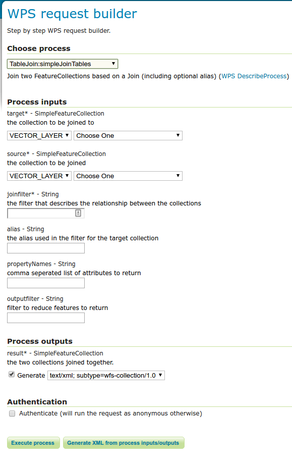
Build the process
- Need to define inputs
- target dataset (Geography)
- source dataset (Table)
- Filter (where clause)
- alias (if needed)
- Or
- target dataset (Geography)
- source dataset (Table)
- XML encoded WFS2.0 Join
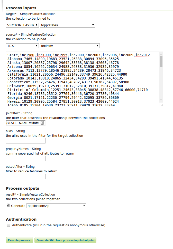
Filters
Simple:
STATE_NAME = State
Complex
A.STATE = STATE
(Set alias A)
strToLowerCase(State) = strToLowerCase(STATE_NAME)
district = substring(0,6,ward)
contains(geom,point)
How do we handle a "Joining" filter?
- Currently GeoTools (and hence GeoServer) has no way of handling these filters (outside of a carefully constructed SQL store).
- But we can reformulate them to work.
- for each feature
- find the attribute value required in the filter
- substitute this into the filter and run against the other dataset to find the match
- if matched add to output
- use a ReplacingFilterVisitor to walk the filter and update.
<?xml version="1.0" encoding="UTF-8"?>
<wps:Execute version="1.0.0" service="WPS" ...>
  <ows:Identifier>TableJoin:simpleJoinTables</ows:Identifier>
  <wps:DataInputs>
    <wps:Input>
      <ows:Identifier>target</ows:Identifier>
      <wps:Reference mimeType="text/xml" xlink:href="http://geoserver/wfsa"
      method="POST">
        <wps:Body>
          <wfs:GetFeature service="WFS" version="1.0.0" outputFormat="GML2"
            xmlns:topp="http://www.openplans.org/topp">
            <wfs:Query typeName="topp:states"/>
          </wfs:GetFeature>
        </wps:Body>
      </wps:Reference>
    </wps:Input>
    <wps:Input>
      <ows:Identifier>source</ows:Identifier>
      <wps:Data>
        <wps:ComplexData mimeType="text/csv">
        <![CDATA[State,inc1980,inc1990,inc1995,inc2000,[...],inc2009,inc2012
Alabama,7465,14899,19683,23521,26338,30894,33096,35625
[....]
Wyoming,11018,16905,21514,27372,32808,40655,45705,48670]]>
</wps:ComplexData>
      </wps:Data>
    </wps:Input>
    <wps:Input>
      <ows:Identifier>joinfilter</ows:Identifier>
      <wps:Data>
        <wps:LiteralData>STATE_NAME=State</wps:LiteralData>
      </wps:Data>
    </wps:Input>
  </wps:DataInputs>
  <wps:ResponseForm>
    <wps:RawDataOutput mimeType="application/zip">
      <ows:Identifier>result</ows:Identifier>
    </wps:RawDataOutput>
  </wps:ResponseForm>
</wps:Execute>
Digression

WPS PPIO
Well no one has added one of these before (except Andrea) but it should be easy enough!
<wps:Status creationTime="2017-08-03T16:17:23.623Z">
  <wps:ProcessFailed>
    <ows:ExceptionReport version="1.1.0">
      <ows:Exception exceptionCode="NoApplicableCode">
        <ows:ExceptionText>Failed to retrieve value for input target
        net.opengis.wfs.impl.FeatureCollectionTypeImpl
        cannot be cast to java.lang.String</ows:ExceptionText>
      </ows:Exception>
    </ows:ExceptionReport>
  </wps:ProcessFailed>
</wps:Status>
Another issue
- It seems that mimeType="text/xml" is ambiguous!
- works if you use mimeType="text/xml; subtype=wfs-collection/1.1"
curl -u admin:geoserver -XPOST -H 'Content-type: text/xml' \
--data-binary @request.xml \
http://localhost:9000/geoserver/ows?service=wps&version=1.0.0&request=Execute

STATE_NAME,STATE_FIPS,SUB_REGION,STATE_ABBR,LAND_KM,WATER_KM,PERSONS,
Illinois, 17, E N Cen, IL, 143986.61, 1993.335, 1.1430602E7, 2924880
Missouri, 29, W N Cen, MO, 178445.951, 2100.115, 5117073.0, 1368334
Arizona, 04, Mtn, AZ, 294333.462, 942.772, 3665228.0, 940106.0, 13
Oklahoma, 40, W S Cen, OK, 177877.536, 3170.998, 3145585.0, 855321.0
Further Work
- Fix remaining issues
- Decide what to do if multiple features match
- error
- many records
- first record to match
- Documentation
- Bring CSVDataStore up to maintained status
Coming Soon to a Repo near you
Thanks to Astun Ltd for funding this work
Slides are at http://www.ianturton.com/talks/tables-foss4g/index.html
Ian Turton, [email protected],  ijturton